There are around 437 informal settlement pockets in Cape Town, a provincial capital in South Africa. Nestled beneath the picturesque Table Mountain, the city is known as a premier tourist attraction, drawing crowds from all over the world to its restaurants, beaches and other attractions. But these same landmarks serve to separate the city’s haves from its have-nots. Apartheid spatial planning, a remnant of an oppressive regime, has kept the poor relatively out of sight and away from public scrutiny. As a result, a lack of proper sanitation and service delivery often goes unchecked in these areas. To bring the plight of city’s poor to the fore, civic technology lab Code for South Africa (Code4SA) created an interactive map that not only highlights the lack of sanitation services in informal settlements, but also allows users to explore two real-life, on-the-ground stories of people living in these areas.
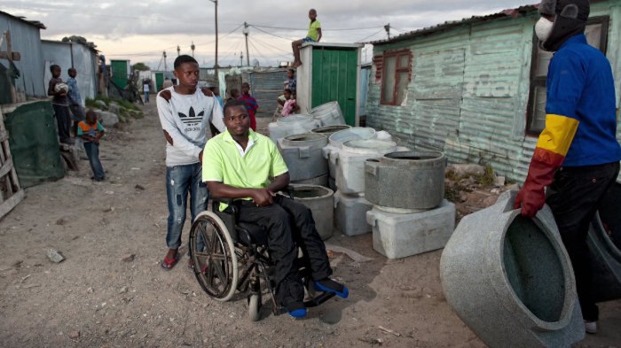
“It’s one thing to look at the numbers and be aware that there are no toilets in an informal settlement. It’s another to see how Asithandile, a disabled resident of the Kosovo Informal Settlement suffers because he cannot access the temporary toilets by himself,” said Guus Hoekman, web developer at Code for South Africa.
The project was conceptualised in April when Code4SA was approached by Ndifuna Ukwazi (NU), a non-profit law centre in Cape Town, to create an online map visualisation of Cape Town’s informal settlements. Using data collected by NU, in partnership with the Social Justice Coalition (SJC) and International Budget Partnership (IBP), Code4SA set out to create an interactive platform that functioned as an experience rather than a collection of data.
“The next step was to make the map interactive,” said Hoekman. “We wanted the map to be an experience, more like a tour of informal settlements than just a boring report of toilets per settlement.”
Developers equipped the map with the ability to switch between individual layers and view parts of the data separately. For example, users can switch between the age of settlements, the number of households and more. Similar to Google Maps, the interactive platform allows users to change between map and satellite view, similar to Google Maps. Most importantly, users are able to click on an informal settlement or pocket and receive detailed information about that area.
“To complete the picture, we added two real life-on-the-ground stories of people living in these informal settlements with poor or no access to sanitation to give the data a human element,” wrote lead Code4SA journalist Julia Renouprez.
The map aims to give citizens an idea of the level of poverty affecting inhabitants in the city’s slums. It also serves as an accessible, easily understandable platform from which residents in informal settlements can hold the government accountable for the lack of services and sanitation in their areas.
Mapping poverty is not a novel concept. The United Nations (UN) is currently using satellite images to map poverty in Africa from space. While gathering data on the ground can be dangerous, researchers have discovered that satellite imagery and machine learning present a worthwhile alternative.
According to Science Mag, researchers have always wondered whether poverty can be detected from space. Using images taken of the planet at night, scientists could roughly determine where the rich and poor live by relying on the glow of electric lights. The method wasn’t foolproof as researchers could not determine the difference between moderate underdevelopment and absolute poverty. To do this, a team of social and computer scientists led by Marshall Burke, an economist at Stanford University in Palo Alto, California, turned to images captured during daylight.
With daytime images, researchers were able to notice subtle clues as to the level of poverty in an area such as proximity to water, agriculture and marketplaces. Turning instead to a computer to make these judgement calls, researchers implemented a machine learning technique called a convolutional neural network. The machine is able to draw conclusions faster and with more accuracy than a human.
While groundwork will still be needed to validate the tool, the technique shows promise.


